IDNDR SPECIAL PROJECT

I-2: Disasters Caused by Floods and Geomorphologic Changes and Their Mitigation
C-1: Prediction of Strong Earthquake Ground Motions, Earthquake Disaster Prediction and Mitigation
C-2: Settlement of Extensometers and Seismographs in the Lishan Landslide, Xian, China
C-3: Mechanism of Viscous Debris Flow and Countermeasures against Debris-Flow Hazards

I-1: Igneous Process and Tectonics

Monitoring fault activity
In Kyoto and Singapore, there are standard gravity stations belonging to IGSN 71(International Gravity Standardization Net 1971),where gravity values at both reference points are precisely given. The stations are Kyoto C(Kyoto University)and Singapore A (Institute of Education of Singapore). We can get a reliable scale factor of a gravimeter by comparing measured gravity difference between both stations with the authorized one. We made gravimetric measurement at both stations with Scintrex CG-3M Gravity Meter in September and October 1995.
Gravity measurements in West Jawa of Indonesia were carried out in September 1995. Using the new scale factor aforementioned, the gravity values at DG.0 (Primary Base Station for Indonesia) in Bandung is redetermined linking to Singapore A and at other many stations near Cimandiri fault(to the west of Bandung), Lembang fault(to the north of Bandung) and Guntur volcano(to the north-east of Bandung). Most of gravity stations are composed of GPS observation sites to monitor the fault and volcanic activities.

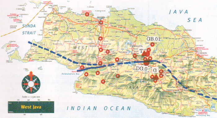
Locations of gravity stations in West Jawa, Indonesia.
Red open circle are locations of gravity stations.
Red triangles are volcanoes( T:Tangkubanperahu; G:Guntur)
Solid lines are active faults(West:Cimandiri;East:Lembang)
Dotted lines are expected tectonic lines(or faults).

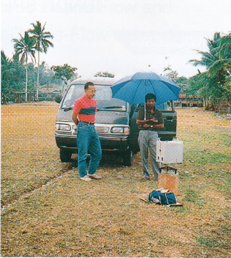
Gravity Measurement at Sagaranten to the
south-west of Bandung. We use an umbrella
protecting gravity meter from heavy sunshine.

There is a base line established by BAKOSURTANAL(National Coordination for Surveys and Mapping in Indonesia) for calibrating scale constants of gravimeters from Bandung to Subang (around 35 km north-east of Bandung) with 275 mgals gravity difference. Gravity measurement is also carried out along this line.
This line passes halfway of Tangkubanperahu volcano. If we repeat precise gravity measurements hereafter, we will be able to distinguish the gravity change caused by the volcanic activity of Tangkubanperahu.
We have repeated gravity measurements in West Jawa three times since 1993. We have not yet distinguished gravity change at any stations. But it is important to repeat and to continue gravity measurements for long period.
We also have surveyed to find out suitable stations for GPS observation around the Guntur volcano in order to monitor its activity and found several points in the region.
In 1996,we are now planning to make GPS and seismic observations in the aforementioned area. More-over we will repeat the international gravimetric connection between Japan, Singapore and Indonesia .By this connection we will be able to get more reliable gravity value at DG.0.

Results in 1995 and plan of operation in 1996 at Guntur Volcano

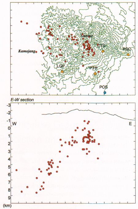
Hypocentral distribution at Guntur Volcano,
West Jawa, Indonesia during November 1994
to March 1996. Hypocenters were determined
by using 4 permanent stations(yellow circles),
assuming homogeneous half Space of Vp=2.76
km/s. Upper and lower figures are epicenter
distribution and projection on vertical cross-
section of east-west, respectively.

Guntur volcano(2249m) is an andesitic volcano complex in West Jawa, Indonesia. The activity is characterized by explosive eruption as the name of Guntur means thunder in Sunda language. In 1840, lava extruded from Guntur crater and flowed down to hot spring Cipanas, 3km apart from the crater. After the big eruption in 1843,no eruptions have occurred at the volcano, however, Guntur volcano is regarded as a high risk volcano because seismicity is high beneath the summit crater and Kamojang caldera at west flank of the volcano complex and many people live in the southeastern part, Garut, Tarogong, Cipanas where pyroclastic flows deposited by pre-historic eruption.
Volcanological Survey of Indonesia(VSI)began seismic monitoring in 1986 by installing a seismometer. Sakurajima Volcanological Observatory(SVO)newly installed 3 seismic stations in October,1994.Volcanic earthquakes observed at Guntur volcano are A-type earthquakes whose P and S phases are distinguished. The hypocenters of volcanic earthquakes are distributed at depths of O-4 km beneath Guntur crater and the epicentral zone continues to the western part. Many earthquakes occurred along the geologic faults around Kamojang Caldera. The hypocenters were located rather deep part, at depths of 5-10 km. The earthquakes beneath the summit crater have small magnitude of <.7 and the magnitudes of earthquakes in Kamojang are bigger up to 3.
We conducted temporary seismic observation by installing 7 additional seismic stations around the volcano from December 18, 1995 to February 5,1996 in order to determine the hypocenters precisely and focal mechanism. Most of the faults are directed to NE-SW near Guntur area. Precise locations of the hypocenters are distributed along the fault and source mechanism is strike-slip fault type whose directions of nodal lines coincide with those of the faults. Although Ramdan began on 22 January according to Muslim, many staffs of VSI spared no effort and joined the observation. Mr. Ony Suganda and Mr. Gede Suantika, who studied at SVO, contributed to installation of observation system and analysis of the data. We appreciate daily effort to maintain observation by 3 observers, Mr. Mamad Sumarna, Rohana and Ade.


In 1996, SVO will conduct seismic observation and precise leveling along the routes installed in 1994 and 1996, The purpose of the leveling survey to grasp deformation rate in dormant period and education for Indonesian researchers and observers. The results of the leveling survey will be processed with continuous tilt observation, EDM and GPS survey.
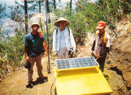
One of the seismic stations at Guntur(PSC).
The electric power is supplied by a solar panel.
The seismic signals are transmitted to Guntur
Volcano Observatory (POS, blue circle in the
figure) and recorded.