
A Brief Review of the Project "Japan-Indonesia Joint Research
on Natural Hazard Prediction and Mitigation"
1. Towards Contribution for IDNDR
It was Professor K.Toki, now at Department of Civil Engineering, Graduate School of Engineering, who made every effort to dwell upon the purpose, significance and objectives of the IDNDR(International Decade for Natural Hazard Reduction) and to urge the necessity of international research collaboration. The concept of IDNDR had been originally proposed by Dr.F. Press, President of the U.S. National Academy of Sciences in 1984; as we should make the last ten years of 20th Century "The decade of International Disasters Reduction" and cooperate with one another to mitigate natural disasters in the world.
Since the reduction of natural hazards is the responsibility of Disaster Prevention Research Institute(DPRI), we agreed naturally to join the international movement of IDNDR and to promote some international joint research projects in order to contribute for the human life in the world. This idea was realized in 1991, and the special international project "Study of Prediction and Mitigation of Natural Disasters in the Eastern Asia(Indonesia and China)" was started as a three-year project.
Here we review one of the two international joint research programs, namely "Japan-Indonesia Joint Research on Natural Hazard Prediction and Mitigation".
2. The First Term(3-year program from 1991 to 1993)
DPRl exchanged "Implementing Arrangements" with Research and Development Center for Geotechnology (RDCG), Indonesian Institute of Sciences(LIPI), and with Institute for Water Resources Development, Ministry of Public Works of Indonesia(RIWRD) to carry out the following three research programs on:
(1) Igneous process and volcanic activity,
(2) Disasters caused by volcanic debris flows, flood and beach erosion and their mitigation, and
(3) Warning and refuge system.
In 1992 another "Implementing Arrangements" was exchanged between Sakurajima Volcanological Observatory and Volcanological Survey of Indonesia(VSI), Directorate General of Geology and Mineral Resources, Ministry of Mines and Energy, in order to carry out our volcanological joint researches more smoothly.
At the Merapi Volcano in the central Jawa a tiltmeter and infrasonic microphone were installed and precursory tilt changes prior to pyroclastic flows have been observed in the program(1), Crustal movements along the Lembang and Cimandiri Faults have also been investigated by repeated GPS surveys in cooperation with ITB and RDGC in(1).
The second program consisted of three sub-themes.
They were:
a) Prediction of debris flows in volcanic areas,
b) Assessment of rain-water and sediment runoffs from volcanic areas and research of flood hazards, and
c) Beach erosion in coral reef beaches and its control.
In a)debris mow movements were observed in the Merapi and Kelud volcanic areas, and prediction methods of debris flow were proposed by numerical simulation of its occurrence, development and inundation. Joint researches on water budget characteristics, flood and sand runoff, and river bed variation were carried out in b)in the upper and middle basins of the Brantas River. Runoff and sedimentary yield models were constructed. Weak points against flood hazard and measures were investigated.
The sub-theme c)includes in-situ observations and data analysis of erosion process at Kuta, Sanur and Nusa Dua Beaches in the Bali Island. The process and mechanism of the beach erosion were made clear, and the basic concept of the measures and practical plans for construction were offered.
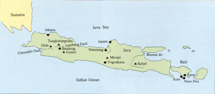
Location of the Japan-Indonesia joint research field
3. The Second Term(5-year program from 1994 to 1998)
We have started the new 5-year program in April 1994, based on the results and experiences obtained in the previous 3-year program mentioned above. The new program consists of the joint researches on:
a) Igneous process of volcanoes and tectonics in Indonesia, and
b) Disasters caused by floods and geomorphological changes and their mitigation.
VSI is the formal counterpart of Indonesian side in the first program
a). ITB and RDCG-LIPI are cooperating with VSI especially in crustal movement studies with GPS measurements and gravity surveys for crustal structure and mass movement investigations under the areas of two active volcanoes, Tangkubanprahu and Guntur. Four seismographic stations have been established and the hypocentral distribution beneath the Guntur has been precisely determined and related with the magma activity. Another tiltmeter has been installed at Merapi. On the other hand a tiltmetric Observation was commenced and six temporary seismographic stations are planned to install at Guntur. Volcanic gas investigations have also been carried out at Merapi, Guntur, Garungun, Gede and others.
The second program b) is being carried out under the mutual relationship between DPRl and RIWRD.
Investigations have been focused mainly in the Brantas and Semarang basins. A hydrological GIS of the Brantas and Solo basins, Solo GIS'95 has been completed. By analyzing the Solo GIS and remote sensing images by MOS-1b Satellite, sediments yield and runoff characteristics have been investigated, and its modeling has been started. In the basin of the Porong river, one of the tributary of the Brantas, a sediment control by using the tidal reservoir is proposed from the investigation of the sediment.
Sea waves and flows have been observed at the Jepara beach since 1993.
The oceanographic observations are planned to shift the target to the phenomena relating to the monsoon. Artificial development of basins, rain runoff, and sediment runoff are analyzed. Wave height estimate, numerical modeling of beach changes and theoretical investigation of near shore current are also being carried out.
We welcome your participation in this joint research program and contribution to the natural hazard reduction in Indonesia.


