IDNDR SPECIAL PROJECT

INDONESIA

I-1 Igneous Process and Tectonics

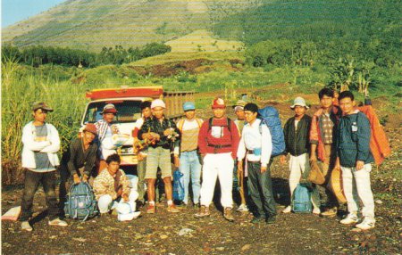
Photo.1 Observation party for the Guntur campaign now departing for Puncak and Leren. The background is the Guntur volcano.w

In order to extend our GPS network to monitor the deformation of the Guntur volcano, Department of Engineering Geodesy, Institute of Technology Bandung(ITB) and Volcanological Survey of Indonesia(VSI) have established 5 new GPS observation points at the Guntur Volcano Observatory of VSI, the top(Puncak), eastern frank(Lereng) and foot(Cikatel) of the Guntur volcano and small village about 4km to the north of the top(Puncak) of Guntur in September 1996 as shown in Fig-1.
GPS observations have been carried out from November 23 to 28. Their positions have been determined as referred to the positions of Leles and BLK which had been obtained in previous campaigns. Observations of the eastern part of the exsisting GPS network which have not observed in the campaign in January 1996. have been carried out from December 2 to December 4, l996. All of these data are now being analyzed. Since the baseline lengths of the Guntur network are rather short, the error of measurements is small as less than 1 mm and a few mm in the horizontal and vertical component, respectively.
In December 1996 gravity measurements were carried out on GPS points at the Guntur network and around Bandung as well as the Lembang fault and the Tang-kubanperahu volcano.
The gravity stations in Indonesia have been tightly connected with the gravity stations which belong to the International Gravity Standardization Net l971 in Singapore and in Japan by four international gravimetric connections including the measurement in 1996.

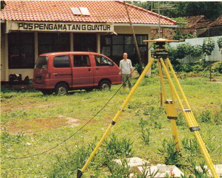
Photo.2 GPS measurement at POS. Guntur network.

Volcanological Survey of Indonesia(VSI) and Sakurajima Volcano Research Center(SVRC) conducted precise leveling survey at the foot of Guntur Volcano, West Jawa in August 1996. The purpose of this survey was to investigate the vertical deformation of the volcano and to practice training of precise leveling survey for Indonesian researchers and observers. They came from VSI, Geological Research and Development Center and Environmental Geology, Directorato General of Geology and Mineral Resources, Ministry of Mines and Energy. Mr.Eto taught the trainees adjustment of the horizontality of the line of sight by Wild NAK-2 automatic level and of circular levels attached to Inver staffs. The exercise along closed route with 4OOm in length was conducted in Bandung prior to leveling at Guntur. The leveling route was constructed in 1994 and 1995 by VSI and SVRC at the south and southeastern foot of Guntur(27 bench marks; I 1.2km long). A part of measurement was made by VSI in 1994. In this time, two sets of Wild NAK-2 and Inver leveling staffs were used bytwo leveling teams. Mean square error for the double runs between each bench mark was +-1.18mm/km. The result of the measurement is not so good due to bad route conditions, high temperature and little training, but the error was much deduced compared with the former survey.
The level of technique of Indonesian researchers is surely improved. The experience of this leveling survey will be helpful to detect deformation at the other volcanoes in Indonesia.

Fig. 1. GPS network at Volcano Guntur. Solid squares are GPS points,
(modified from Ishihara et al. (1996): Annuals, DPRI, 39B-1, 161-171.)

In 1996 fiscal year, SVRC invited 4 researchers from VSI. Dr.Ade Djumarma visited Japan to discuss hazard mitigation programs in October.
In January l997, Dr.Wimpy Tjetjep, director of VSI, Mr.Igan Sutawidjaja and Mr.Gede Suantika belonging to Sumatra and West Jawa section were invited especially for the annual meeting of DPRI. Mr.Igan talked about the recent activity of Klakatau volcano(1992-1996) and Mr.Gede analyzed seismic data obtained by the network installed by SVRC and had presentation about hypocenter distribution and source mechanism. Dr.Wimpy Tjetjep spoke on the topic of "Evaluation of the Japan-Indonesia cooperation in volcanology during the period of l993-1996" in the IDNDR special session. Summarizing that the cooperation in the past has reached almost all targets that has been set up in the plan and benefit have been obtained by both sides in better understanding volcanic phenomena scientifically, he mentioned as follows;
(1) VSI expects a stronger push by Japanese colleague to Monbusho for more VSI!Gs to attend long term training in university and also to give opportunity for potential VSI's personnel to take doctoral level.
(2) DPRI in encouraged to be involved in enhancing monitoring capability in other volcanoes outside Guntur and Merapi and in strengthening ground deformation monitoring in Guntur remains priority to complete the existing one.
(3) Skill training is hoped for VSI's personnel in practical knowledge such as programming, instrumentation and electronics
(4) Application of GPS has not been implemented fully.
Therefore it needs more attention in order to this type of technology to be used in monitoring of Indonesian volcanoes.
Dr.Wimpy reported the activity of Merapi volcano going on explosive eruption on January 17.On 14 January, VSI issued the highest alert-level to local government and 8,000 people successfully evacuated. In addition, Dr.Wimpy gave newspapers one comment "Merapi is now very sick" one day before the explosion, For this precaution. the tiltmeters we installed near the summit were the most important.
Research Center for Earthquake Prediction also invited Dr. Joenil Kahar, Professor at ITB to the special session on January 29, 1997. Prof. Kahar reviewed our first and second joint research programs and the results from GPS campaigns for monitoring crustal movements and the prospect in the future under the title of "Implementation of research cooperation between Disaster Prevention Research Institute and the Institute of Technology of Bandung".

Photo.3 Gravity measurement at Lembang gravity station. Photo.4 Members of VSI and SVO leveling team at Bench Mark CKTD7 near Cipanas at the foot of Gunter Volcano on August 1996.

@ @