


2015 Sakurajima Volcano Crisis – Eruption Alert Level 4
- Other
Since the beginning of 2015, Sakurajima volcano explosive eruptions have been frequent. On 15 August 2015 the eruptions warning upgraded to alert level 4 and residents nearby were informed to prepare for evacuation. Concerning this warning, on 4 September 2015, Dr. Masato Iguchi, Professor and Director, Sakurajima Volcano Research Center, Disaster Prevention Research Institute (DPRI), Kyoto University was consulted to share his opinion on the situation.
 August 2015 and Beyond at Sakurajima Volcano –

It is an unusual situation —–
Sakurajima Volcano is the most active volcano in Japan and one of the most active in the world. Since the beginning of the eruptive activities in 1955 at Minami-dake (South peak) crater, it has erupted over 7,900 times. In 2006, the center of activities moved to the Showa vent, east of Minami-dake and the eruptions since 2009 have been intensifying to a pace of 1,000 times a year. On the other hand, the “A-type earthquakes” generated by shear fracture have decreased. The Showa vent has almost been blocked up by volcanic discharge and the explosive power is increasing due to the heightened volume of magma underneath which may rise up through a path different from a conventional vent. He added that the magna now appears to be static.
Having said that, the swarms of A-type earthquakes that occurred on 15 August 2015 were unexpected. First earthquake was at around 7:00 am and continued to increase by 8:00 am. There was rapid ground deformation. With the data obtained from tilt and strain observation on the Showa crater, changes could be seen in the precursor by around 0.1 microradians or microstrains.
Main concern was change in ground deformation by 0.1 microradians in just 20 minutes and within one hour it has reached 1 microradian. By 10:28 am this was further accelerated to 28 microradians per hour. By the time the uplifting inclination stopped on midnight of the 17th, it has reached 56 microradians. This could only mean the increase of magma underneath. The 15th morning, the day on which the ground deformation accelerated, there were 887 A-Type tectonic earthquakes and on 16th there were 73 earthquakes among which there were 4 felt earthquakes (seismic intensity of 2-3 was observed by the Sakurajima Volcano Observatory). One may think this is a trivial phenomenon considering the seismic activities of tectonic earthquakes around the world but among volcanic activities, it is a dangerous sign. For Sakurajima which has only A-type earthquakes, earthquakes of this intensity within less than a year are very unusual. The seismic activities are concentrated in a depth of 1-3 km directly below Minamidake.
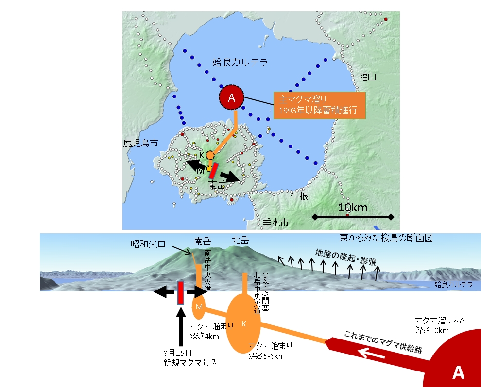
The ground deformation spatial patterns were also different from the conventional patterns. Previously, ground deformation was almost even in all directions. This time, it was observed from the Minami-dake summit to the northwest and southeast direction, about a 5 cm displacement southeast, and there was hardly a displacement in the north-east and south-west directions. In other words, from the northwest – there had to be a large deformation of antisotropy, such as a tearing towards the southeast direction of Sakurajima. From the analyzed data taken from the Daichi-2 advanced land-observation satellite (ALOS2), it was observed that the land has expanded in both east and west side of the Minami-dake vent. Deformation data suggested a dike intrusion beneath Minamidake crater. The depth of the dyke was very shallow, 1-3 km below sea level. The amount of intrusion magma was estimated to be about 2 million cubic meters.
From the precise levelling data analysis, there is an increase in the volume of magma underneath of the Aira caldera. The magma volume is 90% full of discharge volume in the 1914 eruption. The magma is stored beneath Aira Caldera; there is a large magma chamber with a depth of 10 km.
The magma supply systems for Sakurajima are from the main 10 km depth reservoir beneath Aira Caldera to the magma chamber in Kitakade. A new magma moves from the deep part below to the shallow of Minamidake along a tensile crack from northeast to the southwest. Intrusions of dykes are usually inferred from hypocenter migration. The extremely high seismic activity was caused by the dyke-like deformation. If the magma intrusion path is conventional, the higher seismic activities would not occur and the ground fluctuations should exhibit isotropic deformation of the conventional path which would intensify eruption.
● Correspondence with the Disaster Prevention Research Institute, Sakurajima Volcano Research Center
I was consulted by the Fukuoka District Meteorological Observatory at around 8:00 am on the 15th August 2015 to inquire about the pros and cons of raising the current alert level from Level 3 (do not approach the volcano) to Level 4 (prepare to evacuate). In a situation such as this, correspondence is vital – the alert level 4 was for residents which are different from alert level 2 and level 3 issued to mountain climbers. Last year when Ontakesan erupted, the mountain climbers took the alert warning as a safety measure – volcanic disaster measures are not intended to be limited to the crater alone but to the surrounding area too. It should be taken seriously. As mentioned earlier, according to the seismic and ground deformation patterns observed at the Minamidake vent at such rapid increasing levels never seen before, in my point of view, the alert level 4 was reasonable. At around 10:15 am, the Fukuoka District Meteorological Observatory and the Kagoshima Local Meteorological Observatory announced the alert level to 4. The evacuation preparation was for residents in Arimura town which is within 3km of the crater and we advised that residents of Kurokami district which is situated to the east of Kagoshima City and within 4 km of the crater should be informed too.
One of the dangerous phenomenon of any explosive eruption of a volcano is the pyroclastic flow. If Showa crater explodes, the pyroclastic flow may run as long as 1 km and may head directly towards the Kurokami district at a speed that could not be estimated. Arimura is hometown for many residents in Kagoshima City. The evacuation preparation information was issued at around 11:50 am in Kurokami and evacuation recommendation was issued at around 16:50. By 18:00 hours, 77 residents were evacuated from the area.
Dr. Masato Iguchi, Professor and Director
Sakurajima Volcano Research Center, Disaster Prevention Research Institute (DPRI), Kyoto University
Further information visit the following links:
Information of the Press Briefing http://www.svo.dpri.kyoto-u.ac.jp/svo/?topic-news-en=summary-of-press-briefing-by-prof-masato-iguchi-at-sakurajima-observatory
http://www.kyoto-u.ac.jp/en/research/forefronts/new/iguchi.html