
I-2: Disasters Caused by Floods and
Geomorphological Changes and Their Mitigation
(Research Activities)
A five-year collaborative research program on the mitigation and control of disasters caused by geomorphological changes in Indonesia is being conducted under the mutual relationship between DPRI (Disaster Prevention Research Institute, Kyoto University) and RIWRD (Research Institute of Water Resources and Development, Ministry of Public Works of Indonesia). This research program is named "Disasters Caused by Volcanic Debris Flows, Floods and Beach Erosion and Their Mitigation", and is referred to by codel-2 in the IDNDR Project.
Observations and modeling of disasters caused by geomorphological changes are being conducted, especially of hazards caused by volcanic debris flows, floods and beach erosion, in order to make assessment and mitigation methods more reliable.
An important aim of this program is to enhance research capabilities and human resource development in the field of natural disaster science in Indonesia and Japan through the exchange of scientists and engineers.
The research activities are being conducted intensively in two main sites: the Brantas and Semarang river basins. An outline of these activities is reported below.
Brantas River Basin:
In September 1994,visiting Japanese researchers (Messrs. Egashira, Takara and Fujita) carried out river sediment sampling at 20 points along the Brantas River and also a geological survey of part of the hillside of Mt. Crue, which is adjacent to the Brantas River. It was found that the sorting mechanism of river material produces a clearly observed reduction in sediment diameter from the upper to the lower reaches of the river.
Ms. Dyah (Ministry of Public Works: PU) was invited to Japan in October 1994 to improve the model for sediment transport and river topography changes, and to discuss sedimentary problems in Indonesia's major rivers.
Mr. Takara also visited a number of institutes in Indonesia in March 1995, to develop a research technique combining satellite remote sensing and GIS (Geographical Information Systems). This is used for flood analysis and for drawing maps of river sediment generation potential and urbanization processes. The Institutes visited were: Remote Sensing Application Center, Indonesian National Aeronautics and Space Institute(Jakarta); RIWRD(Banding); Experimental Station for Rivers(Surakarta); Solo River Water Supply Project, Solo River Basin Development Main Project (Bojonegoro); Brantas River Basin Development Executing Office(Surabaya); and Center for Data Processing and Mapping, PU(Jakarta).
Satellite image data from MOS-1b were purchased in Japan for remote sensing of the Brantas river basin.
Semarang Basin:
The research aim in this basin is an investigation of the sediment budget and biological situation in the East Semarang basin and the Semarang-Jepara coast as well as prediction models for disasters caused by geomorphological changes. The results will be used to propose a method of environmental preservation and sustainable development in this basin. The following activities are in progress:
1.Observation and Data Analysis.
(a)A one-year observation of waves and currents by Wave Hunter in the Jepara coast during the period of December,1994 to November,1995.
Mr. Yoshioka (DPRI) visited Semarang in December, 1994 for the first exchange of memory packs and batteries, and also gave data analysis instruction at RIWRD, Bandung.
(b)Fine sediment diffusion and transport processes from rivers are monitored using satellite images.
Analysis of wave data obtained by satellite is also conducted by DPRI.
(c) Wind field analysis based on data observed along the Java Sea coast has been done by RIWRD.
2.Prediction of Wind-Waves in the Java Sea
Prediction of significant wave height fields in the Java Sea has been done using the SMB method.
Numerical prediction of spectral wave fields in the Java Sea is also being conducted by DPRl and Hasanuding University.
3.Simulation of Tide-and Wind-Induced Currents
The tide-and wind-induced current field will be computed by the horizontally two-dimensional numerical model of DPRl, to estimate fine sediment transport by the tide. Fine sediment diffusion and transport by the currents are computed as the annual residual of sediment movement from the rivers.
4.Simulation of Nearshore Currents and Beach Changes
Both near-shore current and beach changes are computed by DPRI's numerical models which consist of wave transformation, current and sediment transport models.
5.Prediction of Sediment Input from Rivers and Long-Term Beach Changes
Changes in sediment generation potential are under investigation, using satellite images and land-use maps. Using these results, long-term and large-scale coastal behavior will be made clear by shoreline-change and sediment-transport models of this coast.
Satellite image remote sensing data from MOS-1b were also purchased to obtain a time series of land use in the Semarang basin. A precipitation observation system consisting of rain meters and a micro-computer has been installed at RIWRD.
Others:
In November,1994, Mr. Dede Sulaiman visited DPRI and attended the International Conference on Coastal Engineering, Kobe, to present our paper on wave transformation in coral flats. In February, 1995, Mr. Suwandi visited DPRl to analyze data on coral transplantation at Sanur beach, Bali, which has continued since 1993.
(Research Sketch)
Field Survey of the East Java Earthquake Disaster
by Yoshiaki Kawata
 At around 1:30 a.m. (local time) on June 3,1994, the eastern coastal area of Java island facing the Indian Ocean was attacked by tsunamis, which had been generated by an earthquake. The epicenter was located at 10.2°S,113.2°E, with a Richter magnitude of 7.2. Twenty to thirty minutes after the occurrence of the earthquake, tsunamis arrived at the coasts. The distance between the epicenter and the coasts was about 250km or more, so that the maximum seismic intensity was only 2 to 3 in residential areas. This was a typical tsunami earthquake. The death toll was 246.
We twice made cooperative field surveys, with researchers from the Meteorological and Geophysical Agency. In July, 1994, we visited four villages:
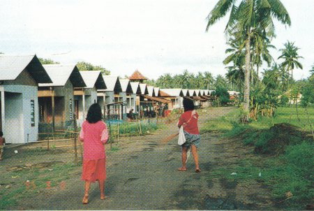
Rajakwesi, Pancer, Lampon and Grajagan at Banuwangi. The main objective of the survey was to make inquiries about psychological stress in the people who survived. About 100 survivors responded to a questionnaire. In March, 1995, we again visited Pancer, where the number of dead due to the tsunamis Was 126.
This was the most severely damaged village. When we visited, a setback line was already set and a buffer zone about 50m wide and 1km long had been artificially made behind the beaches. The residents in the zone agreed to move to new houses prepared by the government. The photograph shows the new houses. At Pancer, about 400 permanent houses were already built at two locations.
We recommended that there should be a new coconut forest in the buffer zone because many fishermen will want to stay near the beaches. Usually, people forget the experience of a disaster after the passing of some years. In order to mitigate the tsunami damage, measures such as construction of a tsunami breakwater, and a tsunami warning system, are recommended.
However, they are very ex-pensive and there are many tsunami-prone areas. If possible, land use management is one of the most effective measures against tsunamis in rural areas in developing countries. In other villages, movement to new houses was achieved, but the new residential areas were in dangerous or inconvenient places-for example, on steep slopes or inland far from the beaches.
Measures against natural disasters must be appropriate to the particular locality. The lessons to be learned from a disaster are therefore very individual' Through discussions between natives, researchers, and government officers, the most appropriate solution can be found to mitigate human and property damage due to any kind of natural disaster. This is the final goal of our international cooperative work.


