Final Report
1994-1998 IDNDR Project

I-2:Disasters Caused by Volcanic Debris Flows,
Floods and Beach Erosion and Their Mitigation


This project had been conducted as a joint research between DPRl and RIWRD(the Research lnstitute for Water Resources Development,Agency for Research and Development,Ministry of Public Works oflndonesia) for studies of flood hazards in the Brantas River Basin,beach erosion and its control in Bali and Java lslands, and comprehensive sediment management in a rivercoast system. The main research results are summarized below.

Fig.1 Simulation of daily rainfall-runoff
hydrograph(upper) and flood runoff(lower)
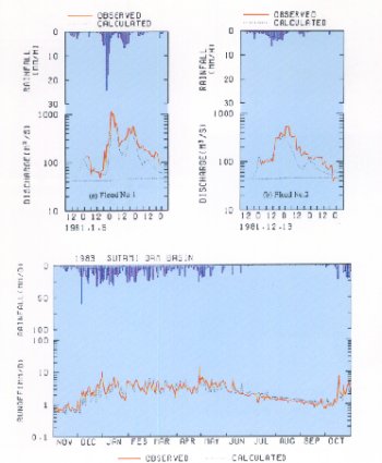
In the Brantas River basin study:
(1) Based on sampling bed materials at about thirty points in the basin, soil property and particle size were investigated. One-and two-dimensional be variation models were constructed for the middle reach of the Brantas. The l-D model investigated the effect of channel width on bed variation and the effect of suspended load, and revealed that the rapid change in channel width causes greater river bed variation, which is critical for flood hazard. The 2-D model expressed the stream bifurcation process in the river and verified that river bed variation and particle size at the inner side become greater when taking the suspended load into account.

(2) Remote sensing images and geographic information systems(GIS)are used for establishing a distributed hydrological model for flood and sediment runoff. The model applied to the Putih river, one of the major tributaries,reproduced the sediment yield during seven years following the 1990 eruption of Mt.Kelud and estimated the effective infiltration depth that contributes sediment yield.

(3) Along-and short trerm rainfall-runoffmodel was also constructed for the analysis of water alance and prediction of runoff discharge in the Sutami reservoir basin. This model can reproduce daily rainfall-runoff, using the VIC(variable infiltration capacity)model.

In the studies of beach erosion control and the prediction ofcoastal and sea bottom topography changes:
(4) One-year simulation oftide-and wind-driven circulation in Java Sea, which is influenced by west-and east-monsoon, was carried out using a three-dimensional hydrodynamics model incorporating the influence of waves. A third-generation ocean wave prediction model, WAM, was employed to calculate the wave fields and the wave-dependent sea surface and bottom drag coefficients. Six hourly wind-field at 10m above the sea surface were given by ECMWF's global climate reanalysis data as a representative wind. The trajectory of numericaltracers for one-year circulation was simulated to make clear transportability of materials at both the sea surface and bottom.

(5) A 3-D beach change prediction model which consists of bore type breaking wave mode1, 3-D nearshore circulation model and sediment transport model, has been developed in this project. Its verification has been continued on coasts both in Japan and in lndonesia.

(6) Coastal monitoring and numerical prediction have been conducted in Pangandaran coast(South Java)facing the lndian Ocean, where the river short-cut works are under construction.

(7) Tsunamis hazards caused by huge earthquake in the Pacific Ocean have been investigated in this project. Counter-measurers against tsunami hazards in lndonesia have also been studied by means of hydraulic experiment for tsunami run-up and land topography changes due to surges.

Details:Proc. of Symposium on Japan-Indonesia IDNDR Project, Volcanology, Tectonics, Flood and Sediment Hazards, 1998.

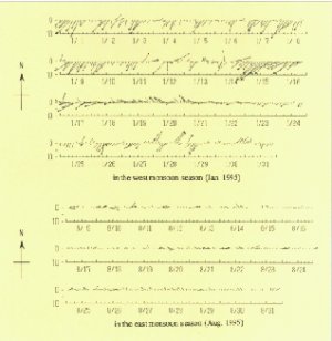
Fig.2 Three-dimensionai simulation of tide-and wind-driven circuiation in Java Sea. The leftfigure shows trajectory particfes on the bottom driven by the west monsoon in 1996 and the right shows trajectory particles on the surface. Fig.3 0bserved time series of coastal current Vector at Jepara Coast in 1995. The upper shows currents under the west monsoon condition and the lower that in the east monsoon.