Chichi, Taiwan Earthquake (Mw 7.7)
Report of a Quick Investigation
J. Mori, A. Ando, H. Katao, S. Ohmi
Research Center for Earthquake Prediction,
Disasaster Prevention Researth Institute, Kyoto University
In the early morning (01:47 Taiwan Time) of September 21, 1999, the largest earthquake of the century in Taiwan (Mw=7.7, ML=7.3) struck near the small town of
Chichi (23.87oN , 120. 75oE). There was significant damage in the towns of ChungLiao, Nantou, Taichung, FengYuen, and Dongshi, with over 2000 people killed and 7000 injured. The earthquake occurred on the Chenlonpu fault which is a north-
south trending thrust that dips shallowly toward the east.
Surface Faulting
There was surface rupture for about 60 km on a north-south trend of the active Chelongpu fault beginning near Chushan in Nantou County in the south and extending
to Fengyuen in Taichung County in the north. Generally 1 - 4 meters vertical displacement was observed along this portion. The faulting appeared to be nearly pure thrust in most places..
Northeast of Fengyuen at the northern end of the rupture, the faulting is complicated and distributed on a number of smaller faults. In this region the trend of the faulting bends toward the east-northeast for about 25 km. There were very large offsets of 4 to 8 meters vertical displacement and 1 - 9 meters of lateral displacement at scattered sites.The displacements may be occurring on several short sub-parallel faults.
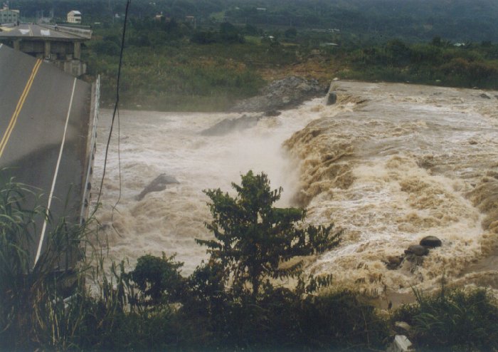 |
New waterfall created by fault offset.
The vertical displacement is estimated to be
about 8 m. |
There were spectacular vertical offsets in the river northeast of FengYuen. At one site near a collapsed bridge, a new waterfall formed from an estimated 8 meter vertical fault offset. About a kilometer from this site, a dam was cut by the fault. The road running along the top of the dam was vertically offset by 8 meters. These displacements are some of the largest surface fault movements observed for earthquakes worldwide.
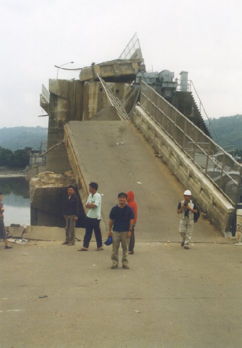 |
Road along the top of a dam that
is vertically offset by fault. |
Earthquake Damage
Throughout the entire region shaking damage was generally greater on the hangingwall (east-side) of the fault. Also, there was greater shaking damage in the southern region than in the north. It is interesting that the surface faulting in the north had the largest displacements but did not cause the strongest shaking damage. The areas near the 8m vertical displacements showed much less shaking damage than expected. Also, instrumental records show that the peak ground accelerations were lower in the northern region compared to the southern region. Most of the structural damage in the north was limited to areas directly on the surface trace of the fault and often caused by ground deformations rather than strong shaking. This intensity distribution is very different from the extensive strong shaking damage caused by the Kobe earthquake. The lack of extensive shaking damage in the north might be explained by vertical movements of the hanging wall that are rather smooth and slow. The observed strong motion data recorded along the fault trace are consistent with this explanation. The stations from south to the north show a significant change of dominant frequency with stations in the south recording higher frequency radiation and stations in north recording lower frequency radiation
In the southern region, there were many collapses of the first story in 2 to 4 story buildings. This was largely due to a soft first story. The first floors had fewer walls with more open areas and were used for parking or businesses.There were many of these collapses in ChungLiao.
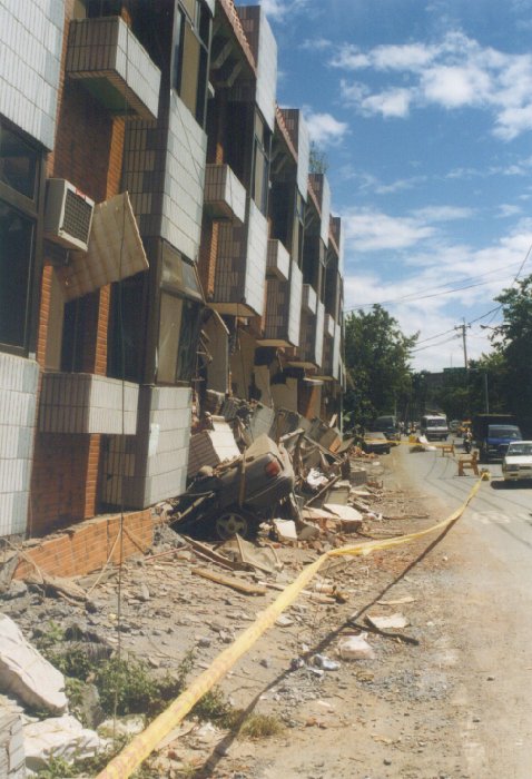 |
Collapse of the 1st floor in a 3 story
building located in Chungliao. |
Many tall buildings in Taichung did not have damage, although there were a few large stuctural failures and collapses that caused casualties. Most large buildings were built in and after the mid 1970's, which is after the improved building codes were established in 1975.
Aftershocks
More than 7000 aftershocks were recorded within five days after the mainshock, including over 200 felt events and five aftershocks of magnitude greater than 6.0. This is one of the stronger aftershock sequences and rather unusual for an earthquake of this size. These large aftershocks affected the people in Taiwan causing panic, damage, and sometimes casualties. During our investigation there was a M6.8 while we were in a large hotel in Taichung. Since we were on the 19th floor we felt a long duration sway of the building.
Rapid Earthquake Information and Strong Motion
The Taiwan Rapid Earthquake Information Release System operated by the Central Weather Bureau (CWB) performed quite well for the Chichi earthquake. Despite the fact that some of the station were temporarily not operating because of telemetry
problems (not related to the earthquake) the system was still able to get a reasonable location, and magnitude (7.25), and distribution of seismic intensities (intensity 5 or 6 at 9 major cities). An email went out to government emergency response centers in Taipei and the provinces within 2 minutes. Although the intensity distribution map was rather sparse because of the problem of missing stations, there was enough essential information for government emergency response to begin quickly. This demonstrated the robustness of the system.
Acknowledgements
This study would not have been possible without the help of Prof. Chyi-Tyi Lee, Institute of Applied Geology, National Central University and Prof. Kuo-Fong Ma, Institute of Geophysics, National Central University.


